|
Well and
Spring Water Quality Assessment
In The
Pike Run Watershed, PA
Lisa Horvath
and Daria Nikitina
Study Area
|

|
Pike Run Watershed located in
Washington County, PA.
Watershed is located in the
California and Ellsworth USGS Quadrangles
The 2000 census lists 774 homes.
This is predominantly a rural area
and as a result public water is not yet available to all
of the residents.
|
Purpose of Study
To determine if
Acid Mine Drainage (AMD) is a non-point source pollutant to the
groundwater system of the Pike Run Area.
There is a long standing history of
coal mining in the area.
Local streams have been assessed and
been determined to contain Abandoned Mine Drainage “AMD”.
Residents use the groundwater as a
drinking water source since public water is not available.
Residents complain of “Rotten Egg”
smell coming from faucets and orange stains on appliances and
dishes
Ions leached which result in AMD
could be linked to serious health problems, such as cancer and
neurological disorders
Initial glances in the area shows a
higher than normal rates of lymphoma and digestive tract cancers
(throat, esophageal, and intestinal), as well as increased
kidney stone cases
|
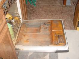
Iron/Sulfur Stained Dishwasher |
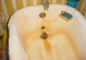
Iron/Sulfur Stained Bath Tub |
Methods
Local residents were asked as
volunteers to participate in a study. This involved sampling
the domestic wells and spring for analyisis compared with
National Drinking Water Standards established by the EPA
(February 2006), This effort resulted in a test of 21wells and
springs.
Each participant was required to
fill out surveys pertaining to their groundwater drinking source
and general health.
Chemical analysis of the water for
this study included pH, temperature, dissolved oxygen,
alkalinity (bicarbonate), hot acidity, conductivity, sulfate,
iron, manganese, aluminum, calcium, and magnesium.
Preliminary studies of 5 randomly
selected sites demonstrated high levels of sulfate, magnesium,
calcium, and iron.
Sample sites were geo-referenced and
plotted into ArcView 9.1 for spatial analysis
Local stratigraphic data was
gathered through local cores drilled in the area by the PA
Turnpike Commission and through observations of local outcrops
Past mining activity information was
gathered to determine the locations of mining pools.
Results and
Findings
The majority of local “springs” are
pipes placed into the collapsed mine entrances. Mining companies
use this method to avoid mine flooding.
Many local residents used this water
sources.
|

SPRING |

SPRING |
Chemistry
Footprints of AMD found
Alkalinity High
Iron Levels High
Aluminum Levels High
Calcium Levels High
Manganese Levels High
Conductivity High
Sulfate Levels test results are
lower than expected. This may be due to the time of year the
samples were collected of perhaps the aquifer is rising.
Causes of
Dewatering Due To Mining

Lithology Column
|
 
|
Initial
Findings:
- Wells above the Uniontown Coal
seem to not be affected by de-watering
- Wells below the Uniontown Coal
do seemed to be affected by de-watering
- Rock under this area very
fractured and disturbed as a result of coal mining
and is also visible in the study area at local
outcrops.
|
Conclusions
AMD is a non-point source pollutant
to the groundwater of Pike Run Watershed.
People are ingesting higher than
recommended standards of ions.
Groundwater Chemistry is directly
related to the local stratigraphy.
Mining activities have changed the
natural confined aquifers of the area.
|


